UPDATE: Due to the updated COVID-19 restrictions which are effective from 11:59pm on Wednesday, 8th of July, this event will be ending on Wednesday, 8th of July. Sorry, if anyone was planning on attending after this date.
5 Transmitters (145.300 MHz) are located within the parkland.
Transmitters are at least 100m from each other, and from the start/finish.
Transmitters are on from 2pm until 4pm each day from Saturday 4th of July until Sunday 12th of July Wednesday 8th of July.
There is no flag or registering device at the transmitters. You will need to use the MapRunF app. To find the event in the app go to Shwerkolt Cottage and press Events Near Me. The event is called “ARDF – Yarren Dheran ScoreRun90 04-07-2020” If you get asked for a PIN enter 6771.
Once you start the event you shouldn’t look at your phone until you finish.
- The best thing to do is to move off the map screen. Select the centre tab (the symbol looks like a clock). This will show you how much time you have remaining, how many controls you have punched and what the last control was. (Note: the start and finish are counted as controls)
- Make sure your volume is as loud as it goes so you know when you have registered as locating a transmitter.
Your time will start when you pass through the start/finish location and MapRunF registers that you were there, your time will end when pass though the start/finish location for a second time. (There is no beacon at the finish.)
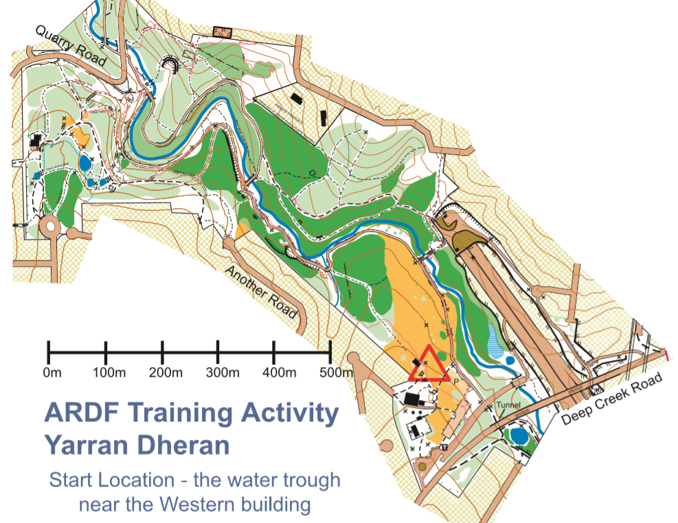
The Map attached to this blog post is far superior to others that I have seen of this area, but if you wish to use others then feel free. (Thanks Geoff for the map.)
Please park in the carpark at Shwerkolt Cottage and walk north west to get to the Shwerkolt Cottage Orchard Shed (The western most building). The start/finish is the water trough north east of the building.
Some warnings
- Do not enter the Freeway.
- There are a number of cliffs in the area. There is no need to attempt to climb up or down any cliff.
- Do not cross any fences. They are often close to the top of the previously mentioned cliffs.
- To be fair to all competitors, please only cross the creek using one of the marked bridges.
- There are hidden hazards in many areas including, logs, rocks, old fences and unmarked low cliffs.
- There is a busy bike path that runs through the middle of the map, please use caution when entering/exiting or swinging your beam on this path.
- Some of the ground is very muddy, spare shoes are recommended for the drive home.
If you venture off a track please be careful.
In case of emergency / technical issues
I will be within approx. 10 mins whilst this event is active.
If you are seriously hurt call 000. If you have a minor injury and require assistance then call me.
If one of the transmitters isn’t working then please contact me, I have a spare transmitter, but it may take 20 mins to program appropriately and get it in place.
Whilst you are in the area
I recommend the donuts at The Pastry Board in Ringwood North, or if you want a sugar overload Pizzeria Express has Donut Snack Packs (DSPs).
Results
Results will be available instantly in the MapRunF app but will also be posted on this page.